Kata Tjuṯa
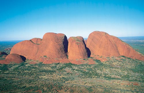
Kata Tjuṯa (Pitjantjatjara: Kata Tjuṯa, lit. 'many heads'; Aboriginal pronunciation: [kɐtɐ cʊʈɐ]), also known as The Olgas and officially gazetted as Kata Tjuta / Mount Olga, is a group of large, domed rock formations or bornhardts located about 360 km (220 mi) southwest of Alice Springs, in the southern part of the Northern Territory, central Australia. Uluṟu / Ayers Rock, located 25 km (16 mi) to the east, and Kata Tjuṯa / The Olgas form the two major landmarks within the Uluṟu-Kata Tjuṯa National Park. The park is considered sacred to the local Aboriginal community. The 36 domes that make up Kata Tjuṯa / Mount Olga cover an area of 21.68 km2 (8.37 sq mi) are composed of conglomerate, a sedimentary rock consisting of cobbles and boulders of varying rock types including granite and basalt, cemented by a matrix of coarse sandstone. The highest dome, Mount Olga, is 1,066 m (3,497 ft) above sea level, or approximately 546 m (1,791 ft) above the surrounding plain (198 m (650 ft) higher
Elevation: 1066 m
Country: Australia
Explore topics:
- Kata Tjuṯa hiking routes
- Kata Tjuṯa best routes
- Kata Tjuṯa camping
- Kata Tjuṯa parking
- Kata Tjuṯa car park
- Kata Tjuṯa difficulty
- Kata Tjuṯa family friendly
- Kata Tjuṯa dog friendly
- Kata Tjuṯa sunrise hike
- Kata Tjuṯa sunset hike
Related mountains in Australia
- Abbott Peak
- Abbotts Lookout
- Abel Peak
- Aberfoyle Sugarloaf
- Abrotanella Rise
- Adams Peak
- Adamsons Peak
- Addicumbene
- Adla Hill
- Airmid Dome